VITAL Construction Research
Florida International University
Conference Proceeding
Publication Types:
Mapping the Technology Usage in Construction Worker Safety Research
Real-time construction site monitoring requires real-time tracking of resources. Recent researches in real-time data collection have transformed traditional construction practices and skyrocketed productivity, safety and quality on site while serving as a basis for tremendous cost savings. This paper studies available literature to identify and map several types of real-time data that can be collected directly or indirectly on a construction site. For some analyses, real-time automated data collected is not feasible and human intervention is required to record desired information. This paper will focus on construction safety and classify the factors that pertain to worker safety. Systematic Literature Review (SLR) method will be used to map the factors and technologies that have been tested on sites for construction safety. The research will explore both hard data (like location and physiological status) and soft data (like attitude and experience of workers, and information pertaining to safety training and safety culture in an organization). This paper will serve as an index for researchers and practitioners working on construction safety or wanting to learn about real-time construction worker safety research. The maps resulting from this study will serve as a guide to understand what data types are required for a specific problem, how to collect them and how the data can be analyzed. The maps will also reveal trends in automation and technologies use in construction safety research with respect to time.
Capturing Human Sensation Using Physiological Sensing Devices to Support Human-Centered Indoor Environment Design
The fundamental goal of any building is to deliver value to humans. A well designed indoor environment could enhance human comfort, health, and productivity, thus delivering high value to the building occupants. However, each occupant is different with different comfort zones or comfort levels. Thus, even the same design could offer different value to different building occupants. Therefore, the value or evaluation of an indoor environmental design should be coupled with a comprehensive understanding of human comfort (i.e., what are the factors that affect the human comfort and how important these factors are). A variety of methods have been developed to solicit information on human comfort. However, existing methods have been criticized of either not accounting for individual human factors (e.g., human sensation, human perception) or lacking real-time responses from the building occupants. Therefore, to address the gap, this paper proposes to use a physiological sensing device to capture human sensation in respond to different indoor environments, thus providing real-time information to support human-centered indoor environment design of the buildings. This paper focuses on using Physiological Status Monitoring (PSM) devices to capture non-intrusive physiological data such as respiration, heart rate and skin temperature, pertaining to the building occupants. Experiments were designed and conducted in different indoor environmental contexts in a classroom of Florida International University. Different combinations of air temperature, relative humidity, air speed, and CO2 levels were designed. A set of building occupants were invited to use the PSM devices to record their sensation data in different environmental settings. The results of the experiments were analyzed and compared against objective physical measurements and traditional subjective measurements. By quantitatively capturing human sensation, which is a vital factor in building design, this research has the potential to provide a better understanding of human building interaction and to facilitate human-centered indoor environment design.
Virtual Reality-based Personalized Learning Environment for Repetitive Labor-intensive Construction Tasks
In recent years, several developments have been made towards improving construction methodology and equipment used so as to facilitate better construction environment and create safer working sites. Yet there always remain repetitive construction tasks demanding heavy physical performance from the workers, seemingly safe at the time of performance but eventually causing musculoskeletal disorders. This research explores an approach to monitor the postural behavior of a subject during a lifting operation and provide personalized feedback to the subject to encourage ergonomically safe lifting technique. Posture was measured by tracking subjects with a Kinect camera. The joints were extracted from the skeleton and ergonomic analysis was performed on the extracted lift data. OSHA offers a guideline for safe lifts but does not provide a quantitative technique of analysis. This method also puts effort to device a way to quantify such guidelines for a given scenario. The main and final goal of this study is to leverage virtual reality as a personalized learning environment in which the subjects can interactively learn about safety from their own data as well as their peers.
Sustainable Safety in Labor-Intensive Operations: An Innovative Perspective
Maximizing safety often means operating a construction site at its highest sustainable level of safety. This sustainable level of safety is of major interest for safety managers because knowledge of such level can help them identify areas and opportunities of enhancing safety on the jobsites. Safety strategies and plans are made by the managers based on their perception of such sustainable safety. No formalized method exists to determine such level of safety for a construction site. OSHA regulations provide a general guideline but do not consider specific site conditions. The regulations also do not provide insight on what can be done beyond the mandatory requirements to maximize the level of safety and what level of safety can be attained and sustained on a site. To address this problem, this paper proposes a novel framework to identify the sustainable level of safety for a given condition at site. The method builds upon a two-way approach in which a theoretical maximum level of safety and observed level of safety govern the sustainable safety at site. The method also intends to explore the inefficiencies at the jobsite and help identify the areas of improvement. The scope of the paper is limited to labor-intensive lifting operation and relies on skeletal data collected by Kinect camera for illustration purposes. The paper outlines the method and the components of the framework and provides an illustration through a lab-based experiment. The method can potentially help the safety managers to improve their strategies based on real data collected from the actual site and set realistic goals for safety management on construction sites. The method can also be implemented to automatically analyze safety and make recommendations based on real-time data collected from the site.
Determining Safety Frontier for Repetitive Labor-intensive Operations: A Theoretical Approach
Safety management is paramount because it does not only pertain to workers’ safety but also impacts productivity, profitability, and employees’ morale directly. Every construction project is unique and safety management strategies developed for one project does not necessarily cater to the needs of another project. To achieve a project-based safety management strategy, this research introduces a novel concept of Safety Frontier – the theoretical maximum level of safety that can be achieved in perfect conditions under good management and typical field conditions. The objective of this research is to identify and isolate the factors affecting worker’s safety while performing labor-intensive operations and propose a method to determine the safety frontier empirically. A Kinect camera was used to record, a sample dataset which was manually annotated to analyze sub-operations. This research only focuses on body posture as a long-term safety issue but it reports the challenges while determining the thresholds for safety and effect of other factors on the overall safety situation. The determination of the highest level of safety can act as a yardstick benchmark to evaluate effectiveness of safety management strategies. It can assist safety managers to formulate adaptive safety management strategies and help them understand the training and supervision needs at construction sites.
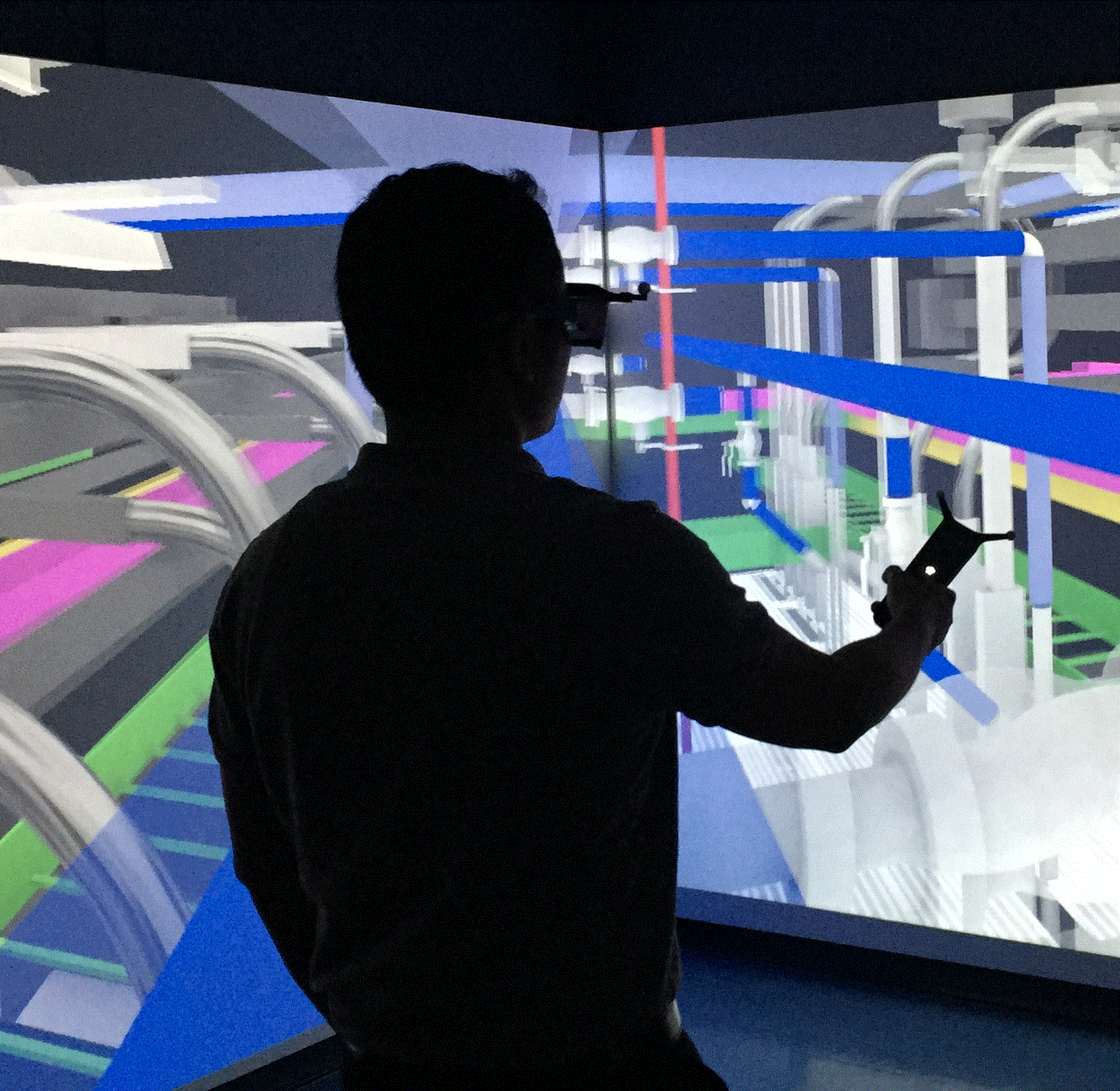
Construction Safety Perception Analysis using Affecting Sensing Technology and Virtual Reality
Virtual Reality (VR) is widely used in conception, planning and design phases of a project, mainly for communication and collaboration. During the construction phase, safety demands major attention at any active construction site. Iterating among alternative safety plans in real world conditions can be dangerous, expensive, resource intensive and often not feasible. Safety is not only governed by what regulations are at place; the perception of the workers towards site safety conditions is also equally important. In other words, in addition to imposing safety rules, it is also equally important that the workers feel safe in their working environment. This paper explores the potential of leveraging VR to investigate on perceptual response of workers on site safety conditions. A VR environment is created based on real-time geometric (laser scan) and location (GPS) data collected from moving equipment and workers at an active construction site. Hazards are introduced into the VR scenes in a systematic and controlled manner. Subjects are exposed to the scenes through a head-mounted VR system. The experience of the subjects in different hazardous scenarios are recorded through Affective Sensing devices and a questionnaire. Affective sensing technology can track human physiological responses in real-time. The goal of this research is to leverage VR environment to (i) test the feasibility of using affective sensing devices for tracking human responses to hazardous situations, (ii) study the potential of exposing construction workers to virtual hazards for training purposes. The results from this study will give a better understanding of potential of VR in construction safety training and management.
A University-based Summer Camp to promote Construction Technology Career for High School Students
This paper reports findings from a pilot summer camp program organized to promote construction-related career, especially construction technology related career, in high school students. The camp introduced concepts from Programming, Virtual Reality, and Construction to students who had little to no experience in these fields. The two-week course followed a Project Based Learning curriculum, which was chosen to increase relevant and deep learning in addition to motivation in the students to learn the concepts. The project that spearheaded the program required the students to design and construct a building in a virtual environment using a programming language. To construct this building, the students had to learn to program, be able to use virtual reality environment proficiently and implement concepts from outside the class curriculum of the course, be able to use spatial visualization to design their structure, and collaborate with each other in order to achieve success. The objective of the program was to entice tech-savvy new generation towards construction, which will eventually expedite technological adaptations in the construction industry. The challenges, findings and recommendations from the program are discussed in this paper.
Eye-Tracking Technology for Construction Safety: A Feasibility Study
A construction site is a harsh environment demanding entire human senses and attention, even for regular scheduled tasks. Many accidents occur on construction sites because of inability of workers to identify hazards and make timely decisions. To understand why some hazards go unseen, it is crucial to study how workers perceive the site. The objective of this research is to leverage eyetracking technology to study workers’ gazing pattern in a construction environment. A real picture from an active construction site is modified to introduce hazards and a desktop experiment is conducted, in which, subjects are asked to identify the hazards. A different group of subjects are made to make similar observations on a 2D sketchrepresentation of the same construction scenario. Eyetracking data gathered from their observations is analyzed to understand when, how, and which hazards do they recognize and the pattern of recognition is studied. The results of this study will enhance our understanding on the visual factors that govern attention and help workers recognize potential hazards in a construction site. The comparison between the observation pattern in real and sketch-representation is done to assess how subjects respond to artificial images compared to real images. This comparison will test the feasibility of using virtual reality for safety training and simulations.
Assessment of Infrastructure Resilience in Developing Countries: A Case Study of Water Infrastructure in the 2015 Nepalese Earthquake
Despite the emerging literature on resilient infrastructure systems, the number of studies related to developing communities is rather limited. The majority of the existing studies focus mainly on resilience of infrastructure networks in developed countries. Infrastructure networks in developed countries are less vulnerable to the impacts of catastrophic disasters due to the existence of established design codes and management processes and the availability of financial and technological resources. Catastrophic disasters usually have more extensive impacts on infrastructure systems in developing countries. The objective of this study is to investigate the resilience of infrastructure in developing countries using a case study of water system in Kathmandu Valley in the aftermath of the 2015 Nepalese Earthquake. First, a new systemic framework for assessment of infrastructure resilience was developed. Second, data obtained from various sources including pre-disaster condition, post-disaster damage assessments, and interviews with different stakeholders were used in assessment of different components of resilience in the water system.The study investigated three dimensions of resilience in Kathmandu Valley’s water system : (1) exposure ; (2) sensitivity ; and (3) adaptive capacity. Through a systemic analysis, various resilience characteristics such as coupling, response behaviors, and types of interdependencies that affect the resilience of the system were identified. The findings of the study highlight different factors that influenced the resilience of the water system in Kathmandu Valley. These results provide new insights regarding infrastructure resilience in the context of developing countries.
Real-time Location Data for Automated Learning Curve Analysis of Linear Repetitive Construction Activities
Learning curve analysis has been used for decades in construction industry to study the effect of experience on productivity, especially in repetitive jobs. Accurate and reliable estimate of time and cost are the benefits of performing a learning curve analysis. While learning curves exist in all levels of a project, detailed analysis of workers’ learning curve for short-term activities (that only span for a couple of minutes) require meticulous manual observation. This demand in manual effort overshadows the economic benefits from such analyses. Also, manual observations are time consuming, subjective and prone to human errors. This research outlines how data for automating such learning curve analyses can be gathered from a construction site. For this purpose, real-time location data using Global Positioning System (GPS) technology is collected from the workers as they perform their regular activities. Data acquired from GPS technology is used with occupancy grid analysis to calculate the amount of time spent by workers in specific area, which is used to demonstrate the spatio-temporal analysis of learning curve. A linear construction activity is presented as a case study. Results include automatic generation and visualization of learning curves for workers. The proposed method enables minute analysis of learning curves in activity level which can be directly associated to project level by following work breakdown structure. The method can be used in construction field for improving estimation, scheduling and training by project managers.
Hazardous Proximity Zone Design for Heavy Construction Equipment
The construction industry continues to be among the leading industries for workplace fatalities in the U.S. After experiencing 824 fatal injuries in 2013, the construction industry continues to rank as one of the most dangerous work environments when compared to other private industrial sectors in the U.S. Conditions of construction sites often produce hazardous proximity situations by requiring ground workers and heavy equipment to operator at close proximity. The gathered injury and fatality statistics indicate that current safety practices of construction workers have proven inadequate. The objective is to design hazard zone around pieces of heavy construction equipment in which ground personnel should not enter during construction operations. The scope is limited to construction sites and equipment at a horizontal grade and hazards between heavy construction equipment and workers-on-foot. A framework for creating the hazard zone around any piece of construction equipment is presented including detailed methodology discussions for each step. The hazard zone for a dump truck, excavator, and backhoe are shown using the created framework. Construction resource tracking data was used to validate the created hazard zone around a dump truck. Results indicate that hazard zones for ground workers can be created around construction equipment to increase hazard awareness for workers. Furthermore, additional safety standards can be formulated based on the ability to design and eventually implement hazard zones on construction equipment.
Global Positioning System Data to Model and Visualize Workspace Density in Construction Safety Planning
Safety as well as productivity performance in construction is often poor due to congested site conditions. We lack a formalized approach in effective activity-level construction planning to avoid workspace congestion. The objective of this study is to investigate and prototype a new Building Information Modeling (BIM) enabled approach for activity-level construction planning that can proactively improve construction safety. The presented method establishes automated workspace visualization in a building information model, using workspace modeling as an integral part of construction safety planning. Algorithms were developed for extracting activity-specific workspace parameters from workforce location tracking data. Global Positioning System (GPS) data loggers were attached to the workers’ hardhats during the stripping activities of formwork of columns. Workspaces were then visualized on a BIM platform. The developed method can support project stakeholders, such as engineers, planners, construction managers, and site workers with the identification and visualization of required and congested workspaces, hence improving the foundation on how decisions are made related to construction site safety and health, as well as its potential impact on a productive, unobstructed work environment.
Automated Collection, Identification, Localization, and Analysis of Worker-Related Proximity Hazard Events in Heavy Construction Equipment Operation
The construction industry measures worker safety performance through lagging indicators such as counting numbers of illnesses, injuries, and fatalities. Active leading indicators, such as
capturing hazardous proximity situations between ground workers and heavy construction equipment, provide an additional metric for construction site personnel safety performance without incurring worker accidents. This article presents an algorithm for recording, identifying, and analyzing interactive hazardous proximity situations between ground workers and heavy construction equipment. Spatio-temporal GPS data of ground worker and heavy equipment movements are analyzed to automatically measure the frequency and duration of identified hazardous proximity situations. Individual periodic ground worker and equipment operator safety performance with regards to exposure to hazardous proximity situations is reported in detail. The results are integrated with previous research on blind spots and other safety deficiencies of the equipment. By measuring and analyzing leading indicator data of ground workers and heavy equipment, safety managers can identify hazardous situations that may otherwise lead to incidents. Knowledge generated about hazardous proximity issues are disseminated to construction personnel through enhanced safety training and education. Mitigation measures can also be taken for safer construction equipment operation.
Passive RFID and BIM for Real-Time Visualization and Location Tracking
Locating a specific utility or finding oneself in an unfamiliar facility can be difficult and time consuming. The ability to visualize the location in real time can reduce the time for manual searching and locating. The proposed research is to utilize commercially available radio frequency identification (RFID) technology for real-time visualization and location tracking in a BIM model. The scope is passive RFID tracking technology and Building Information Modeling (BIM). A novel approach is presented that utilizes current localization techniques and algorithms. A prototype application has been developed that connects the RFID readers with a BIM model and database. Preliminary results demonstrate the feasibility of locating a user inside buildings in actual time. Significantly, the visualization will enable users to pinpoint themselves and a utility in a model, saving time and money.
Development of a Cell-based Simulation Model for Earthmoving Operation using Real-time Location Data
Simulation is a proven technique for effective construction site layout planning and resource optimization. Historical data is used as input for task durations in traditional simulation approaches. These data are fed into activity cycle diagrams that do not consider spatial constraints. Cell-based simulation with real-time location data can be implemented for more realistic modeling and incorporating spatial changes on the site during project execution. Despite the potential, very little research has been done. The objective of this research is to develop a framework of utilizing real-time data for spatial simulation of cyclic activities on a construction site. Continuous data were collected using a global positioning system, and a cell-based simulation model was developed for spatial consideration of earthmoving cycles. The potential of analyzing and visualizing the effects of varying resource combinations on productivity and traffic congestion onsite were explored. The approach will aid in increasing insight and awareness for decision making in resource management, site layout, and internal traffic control plan. It also will serve as an education and training tool for project managers.
Congestion Analysis for Construction Site Layout Planning using Real-time Data and Cell-based Simulation Model
Simulation models are typically developed for construction operations to maximize output of resources and minimize operational cost. Traditional simulation methods deal with development of activity cycle diagrams based on key activities in construction operations. These methods do not consider spatial constraints at the site directly. As a result, spatial conflicts occur and desired output level is not achieved. Congestion analysis in construction site layout planning depends upon such spatial constraints and movement of resources inside the site. This research implements a cell-based simulation model with spatial consideration for construction site layout planning. The objective of this research is to incorporate congestion analysis into simulation process to improve construction site layout plan. A case study is done involving cyclic earthmoving operation. Location data from moving equipment is collected using Global Positioning System for accurate spatial reference. Real data from site is fed into the simulation model for realistic representation of the operation. A cell-based continuous simulation model is developed for visualizing congestion. A new method for quantifying congestion is proposed. This method will help decision-makers in developing a site layout plan based on movement of resources. The potential for congestion can be determined before implementing a layout onto the site. It will aid in comparing alternative site layout plans and provide insight on consequences of varying the number of resources on site congestion. It will also serve as a training and educational tool for construction managers.
Automatic Fall Risk Identification Using Point Cloud Data in Construction Excavation
Safety continues to be among the top issues in the construction industry after experiencing 775 fatalities in 2012. Among all those fatalities, falling has been considered as one of the leading contributors for several years. This paper presents a method that automatically identifies fall risks on construction sites under excavation by utilizing laser scanning technology. It first extracts safety rules that are related to fall risks from OHSA standards and construction best practices. Then, it collects sets of point cloud data of a construction site under excavation using laser scanning, registering and cleaning the point cloud data afterwards. Finally, it develops an identification algorithm based on those rules and applies the algorithm onto the data to identify potential fall risks by analyzing geometrical properties. An experimental trial is also conducted in this paper and results show that the method successfully identifies those fall risks. The presented method can actively monitor the fast changing situations of construction sites under excavation and provide inspectors and project managers with valuable information about fall risks, helping them make good safety decisions and prevent fall accidents and fatalities.
Automatic Cave-in Safety Risk Identifcation in Construction Excavation
Safety continues to be among the top issues in the construction industry after experiencing 738 fatalities in the United States in 2011. Among all construction operations, excavation is one of the most hazardous because of its possible cave-ins, contact with objects and equipment, bad air, and so on. Until today, most safety inspectors still are inspecting the site manually, making the inspection time consuming and error prone. This paper presents a method that automatically identifies cave-in safety risks in construction excavation. It first extracts relevant safety rules from OHSA standards and industrial best practices. Then it collects a set of point cloud data of a construction site under excavation using laser scanning, registering, and cleaning the point cloud data afterward. Finally, it develops an automated identification algorithm on the basis of those rules and applies the algorithm to the data to identify potential cave-in risks by analyzing geometrical properties. An experimental trial also is conducted in this paper, and results show that the method identifies those cave-in risks successfully. The presented method actively monitors the fast changing situations of construction sites under excavation and helps inspectors and project managers make good safety decisions, preventing accidents and fatalities.
Automated Evaluation of Proximity Hazards Caused by Workers Interacting with Equipment
Previous research and applications in construction resource optimization have focused on tracking the location of material and equipment. There is a lack of studies on automated monitoring of the interaction between workers and equipment for safety purposes. This paper presents a new approach for measuring the safety performance of construction personnel particularly when they work in very close proximity to moving equipment as well as static hazards such as chemical and flammable substances. A method of generating hazardous zones according to the geometric and kinematic characteristics of the considered hazard is introduced. The spatio-temporal relationships between the hazardous zones and workers’ positioning data collected by real-time location sensing technology are automatically analyzed. This approach has been validated in a controlled test bed environment that simulates a construction site. Results indicate that worker’s safety performance of selected activities can be automatically and reliably measured using the developed approach. Furthermore, a heat map is generated for visualizing proximity related issues in the test bed using the computed results.
Spatio-Temporal Safety Analysis of Construction Site Operations using GPS Data
Recording the continuous location of equipment and workers with Global Positioning System (GPS) units can contribute in the analysis of how safely a construction site operates. Automated data gathering and analysis for safety become even more valuable when reliable methods exist that record and report events that otherwise would not be recorded because they are labor intensive in observation or prone to human error in judgment. This paper presents a new safety approach that features automated analysis of continuously collected proximity data between construction workers, heavy construction equipment, and hazardous construction spaces in outdoor construction environment. We recorded field data using small GPS units that were mounted on construction helmets or attached to construction equipment. This paper first evaluates the performance of the technology that was used to gather continuous location data to construction resources (workers and equipment). It then explains how the generated spatio-temporal information can be communicated to decision makers so it improves the safety performance of workers near equipment or other hazards. The results that are presented include a case study to outdoor construction environment. It demonstrates how potential users can measure the safety performance of construction resources (workers, equipment) automatically and use the generated information as new knowledge in safety training and education.